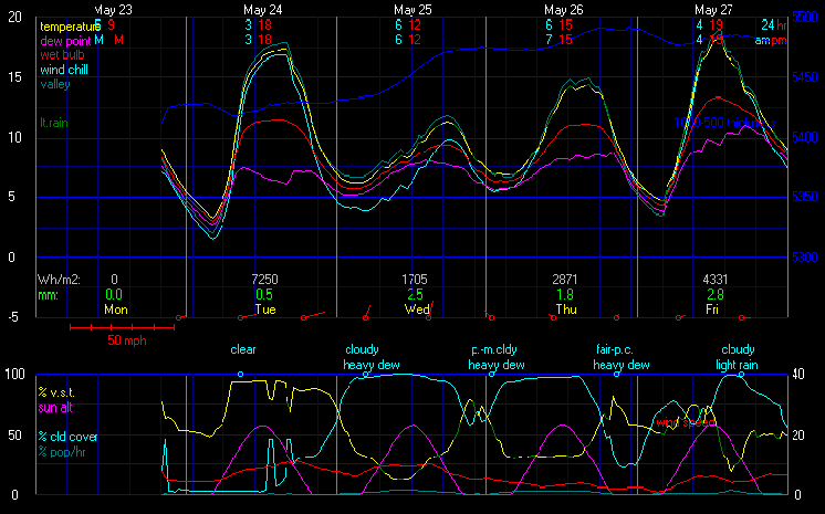
This graph represents the most recent WXSim forecast
GraphCast Interpretation
Top Graph
| Temp | The "24hr" temperatures are the low and high values from midnight to midnight. |
| AM/PM temps are defined as follows: Min is from 7PM the preceding day until 7AM of the current day.
Max is from 7AM through 7PM of the current day. Usually, the two types of reports give the same results, but in winter, with fronts moving through, there will be differences. NWS forecasts use the AM/PM system (as do these forecasts), but the official climate data is generally midnight-to-midnight. |
| Dew Pt | Dew Point is the temperature at which the air can now longer hold all of its water vapor. |
| DP is a better indicator over Humidity of how muggy or dry it feels. Fog usually occurs when OAT/DP are w/in about 1.3 of each other and winds are <4mph. |
| Wet Bulb | This temperature is the lowest temp that can be reached by the evaporation of water. |
| It is the temperature you feel when your skin is wet and is exposed to moving air. Wet bulb temperature is an indication of the amount of moisture in the air. |
| 850 mb | This temperature shows weather conditions at around 5000ft above sea level. |
| Forecasting Surface High using the 850mb Temp and SkewT. |
| Boundary Layer | The air layer near the ground affected by diurnal heat, or moisture, to or from the surface. |
| Temp Adv | Refers to change in temp caused by movement of air by the wind. |
| Forecasting temperatures using advection involves looking at the wind direction at your forecasting site and the temperatures upstream (in the direction from which the wind is blowing). If temps are warmer, that means warmer air is being transported towards your station and the temperature should rise. |
Bottom Graph
|
Used to assess 850 mb parcel instability. The more -ve the LI the more unstable the troposphere and the more buoyant the acceleration will be for rising parcels of air. (using the SkewT) is better at assessing instability in the troposphere as a whole. |
Script courtesy of: Lee from MadALwx.