
| Weather Data | |||
|---|---|---|---|
| LAST READING AT TIME: 21:30 DATE: 15 July 2026, time of next update: 21:45 | |||
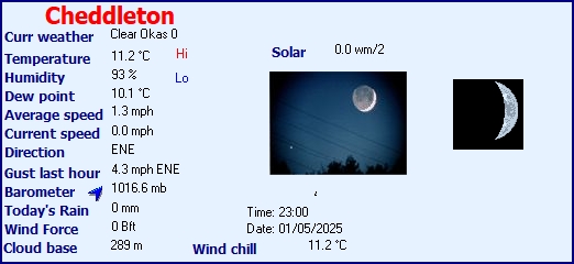
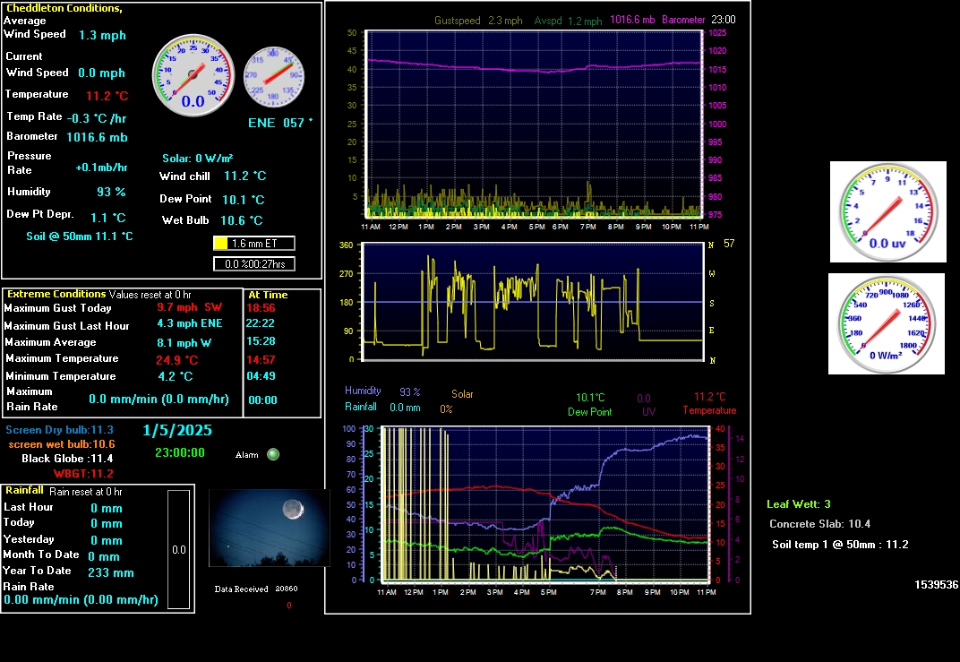
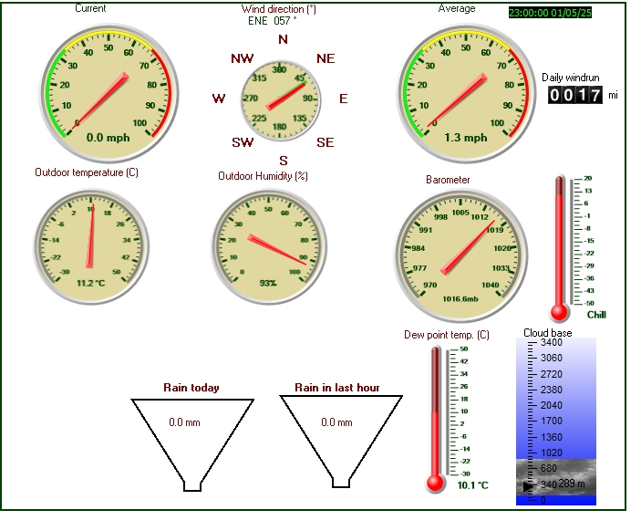
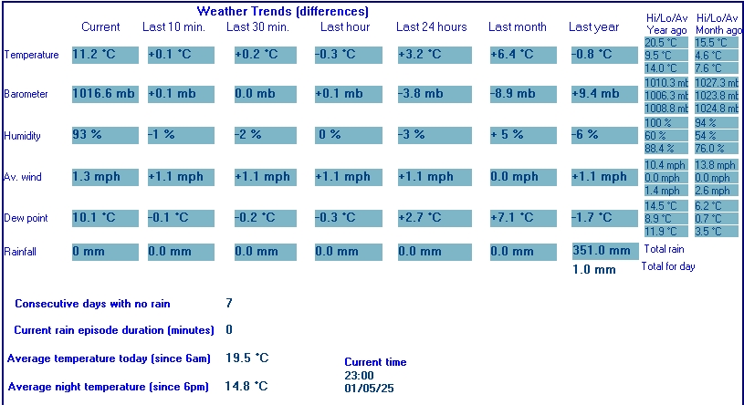
| Current Weather | Clear Okas 0 | Current Temperature | 14.4°C (57.9°F), Apparent temp 15.2°C |
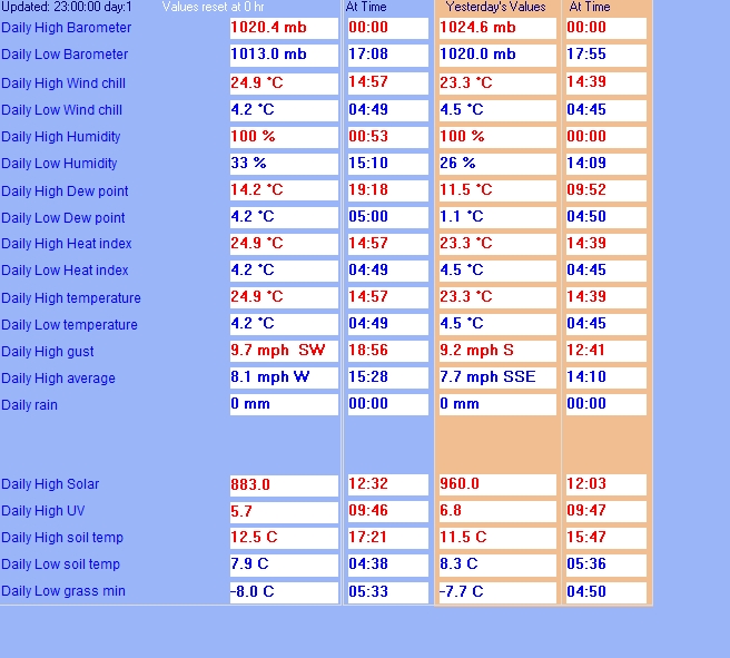
| Maximum Temperature (since midnight) | 24.7°C at: 15:21 | Minimum Temperature (since midnight) | 13.1°C at: 03:55 |
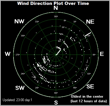
| Average windspeed (ten minute) | 0.6 mph | Wind Direction (ten minute) | NE (45°) |
| Windchill Temperature | 14.4°C | Maximum Gust (last hour) | 4.0 mph at: 21:23 |
| Maximum Gust (since midnight) | 13.0 mph at: 10:26 | Maximum 1 minute average (since midnight) | 10.6 mph at: 17:06 |
| Rainfall (last hour) | 0.0 mm | Rainfall (since midnight) | 0.0 mm (0.00 in.)--- |
| Rainfall This month | 3.2 mm (0.13 in.) | Rainfall To date this year | 563.6 mm (22.19 in.) |
| Maximum rain per minute (last hour) | 0.0 mm/min | Maximum rain per hour (last 6 hours) | 0.0 mm/hour |
| Yesterdays rainfall | 0.0 mm | DewPoint | 12.4°C (Wet Bulb :13.3°C ) |
| Humidity | 88 %, Humidex 16.9°C | Barometer corrected to msl | 1025.1 mb |
| Pressure change | +0.4 mb (last hour) | Trend (last hour) | STEADY |
| Pressure change (last 12 hours) | -1.5 mb | Pressure change (last 6 hours) | +0.6 mb |
| Current Black Globe Heat temperature temperature 14.7°C | |||
| Maximum Black Globe Heat temperature temperature (since midnight) | 38.6°C | Minimum Black Globe Heat temperature temperature (since midnight) | 13.2°C |
| Current Screen Dry bulb temperature 14.5°C | |||
| Maximum Screen Dry bulb temperature (since midnight) | 24.2°C | Minimum Screen Dry bulb temperature (since midnight) | 13.3°C |
| Current Screen Wet Bulb temperature 13.5°C | |||
| Maximum Screen Wet Bulb temperature (since midnight) | 19.6°C | Minimum Screen Wet Bulb temperature (since midnight) | 12.9°C |
| Current 01:47 hours of sunshine today, current sky: Clear Okas 0 | |||
| Sunshine hours for the year: | 173:15 hrs | Sunshine hours for the month: | 36:45 hrs |
| Current evapotranspiration rate 4.2 mm per day. Yesterday's reading 5.8 | |||

   WXSIM text forecast for Cheddleton, initialized at  5:17 PM Jul 14, 2026
 _______________________________________________________________________________

 Tonight: Partly cloudy. Light to moderate fog after midnight. Breezy. Low 13.
 Wind east-northeast around 12 mph, gusting to 23 mph. Minimum freezing level
 3600 meters above sea level.

 Wednesday: Sunny. Breezy and unusually hot. High 28. UV index up to 6. Wind
 east-northeast around 12 mph, gusting to 22 mph. Maximum freezing level 3650
 meters above sea level.

 Wednesday night: Clear in the evening, becoming fair to partly cloudy after
 midnight. Low 14. Wind east-northeast around 10 mph, gusting to 20 mph, in the
 evening, becoming 5 mph after midnight. Minimum freezing level 3250 meters above
 sea level.

 Thursday: Partly to mostly cloudy. Warm. High 27. UV index up to 5. Wind
 east-northeast around 8 mph, gusting to 17 mph. Maximum freezing level 3400
 meters above sea level.

 Thursday night: Partly cloudy in the evening, becoming fair to partly cloudy
 after midnight. Low 14. Wind east-northeast around 8 mph, gusting to 15 mph, in
 the evening, becoming 3 mph after midnight. Minimum freezing level 2950 meters
 above sea level.

 Friday: Partly to mostly cloudy. Warm. High 24. UV index up to 5. Wind north
 around 6 mph. Maximum freezing level 3100 meters above sea level.

 Friday night: Partly cloudy in the evening, becoming partly to mostly cloudy
 after midnight. Low 13. Wind north-northeast around 6 mph in the evening,
 becoming 2 mph after midnight. Minimum freezing level 3000 meters above sea
 level.

 Saturday: Partly to mostly cloudy in the morning, becoming mostly cloudy in the
 afternoon. A chance of rain. High 22. UV index up to 4. Wind west-northwest
 around 5 mph, gusting to 16 mph, in the morning, becoming north-northeast around
 9 mph, gusting to 20 mph, in the afternoon. Chance of precipitation 30 percent.
 Precipitation mostly less than 2 mm. Maximum freezing level 3300 meters above
 sea level.

 Saturday night: Mostly cloudy in the evening, becoming partly cloudy after
 midnight. Low 11. Wind northeast around 10 mph, gusting to 21 mph, in the
 evening, becoming 4 mph after midnight. Minimum freezing level 2400 meters above
 sea level.

 Sunday: Partly cloudy in the morning, becoming partly to mostly sunny in the
 afternoon. High 22. UV index up to 6. Wind north around 6 mph, gusting to 16
 mph, in the morning, becoming 10 mph, gusting to 19 mph, in the afternoon.
 Maximum freezing level 2950 meters above sea level.

 Sunday night: Partly cloudy in the evening, becoming partly to mostly cloudy
 after midnight. Low 10. Wind north around 7 mph, gusting to 19 mph, in the
 evening, becoming northwest after midnight. Minimum freezing level 2950 meters
 above sea level.

 Monday: Partly cloudy. A slight chance of rain. Breezy. High 22. UV index up to
 5. Wind west-northwest around 11 mph, gusting to 22 mph. Chance of precipitation
 less than 20 percent. Precipitation mostly less than 2 mm. Maximum freezing
 level 3650 meters above sea level.

 Monday night: Fair to partly cloudy in the evening, becoming mostly clear after
 midnight. Low 10. Wind north-northeast around 4 mph, gusting to 17 mph. Minimum
 freezing level 3650 meters above sea level.